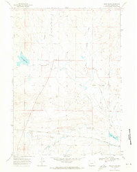
1968 Map of Smith Flats
USGS Topo · Published 1973About this map
The Burlington Northern corridor defines the southern landscape of this Wyoming region, tracing a path through the small settlements of Bucknum and Middle. This era of the late 1960s shows a transition in transportation infrastructure, where the Old Railroad Grade runs nearly parallel to the active line, marking the evolution of the western rail network. The drainage patterns of the North Fork Casper Creek and Middle Fork Casper Creek dominate the central plains, leading toward the Smith Flats upland.
Find a feature on this map
25 named features on this map. Tap any name to fly to it.
Don’t see what you’re looking for? This feature index may not catch every label — zoom into the map to look around manually.
Map Details
Editions of this 1968 Smith Flats Map
2 editions found
Other maps of this area

1950 · Emigrant Gap NE
USGS Topo · 1:24,000

1951 · Emigrant Gap NW
USGS Topo · 1:24,000

1952 · Bishop
USGS Topo · 1:24,000

1955 · Arminto
USGS Topo · 1:250,000

1955 · Casper
USGS Topo · 1:250,000

1958 · Casper
USGS Topo · 1:250,000

1958 · Arminto
USGS Topo · 1:250,000
1960 · Bishop
USGS Topo · 1:24,000
1960 · Emigrant Gap NE
USGS Topo · 1:24,000

1962 · Arminto
USGS Topo · 1:250,000