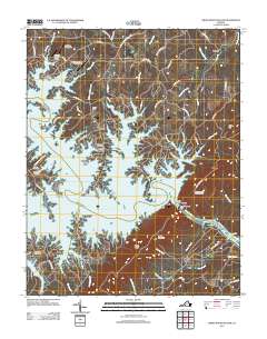
2012 Map of Smith Mountain Dam
USGS Topo · Published 2012About this map
Smith Mountain Dam serves as the focal point of this hydrologic landscape, where the Roanoke River is impounded to form the sprawling fingers of Smith Mountain Lake. This 2012 snapshot of Bedford County reveals a community shaped by the water, with recreational hubs like Eagles Roost, Bernards Landing, and Saunders Marina lining the complex shoreline. The map provides significant genealogical value, documenting numerous family and community burial sites such as Staunton Cemetery, Parker Cemetery, and Blankenship Cemetery, which remain preserved even as the surrounding area transitioned into a vacation and residential destination. Infrastructure like the Smith Mountain Lake Airport and the Lakeview Aerodrome suggest the region's accessibility, while higher elevations are marked by the Smith Mountain Lookout Tower and the prominent Broad Ridge. Local travel is dictated by winding routes like Smith Mountain Lake Pkwy and Tolers Ferry Rd, which follow the ridges between deep lake coves.
Find a feature on this map
78 named features on this map. Tap any name to fly to it.
Don’t see what you’re looking for? This feature index may not catch every label — zoom into the map to look around manually.
Map Details
Editions of this 2012 Smith Mountain Dam Map
This is the sole edition of this map. No revisions or reprints were ever made.
Other maps of this area

1890 · Roanoke
USGS Topo · 1:125,000

1891 · Roanoke
USGS Topo · 1:125,000

1892 · Lynchburg
USGS Topo · 1:125,000

1921 · Chatham
USGS Topo · 1:48,000

1922 · Callands
USGS Topo · 1:48,000

1923 · Chatham
USGS Topo · 1:62,500

1924 · Callands
USGS Topo · 1:62,500

1944 · Callands
USGS Topo · 1:62,500

1947 · Roanoke
USGS Topo · 1:250,000

1951 · Moneta
USGS Topo · 1:62,500