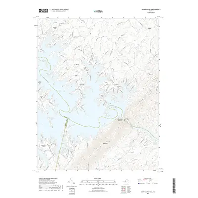
2019 Map of Smith Mountain Dam
USGS Topo · Published 2019About this map
Smith Mountain Dam anchors the landscape where the Roanoke River cuts through the Gap of Smith Mountain, creating the sprawling reservoir that defines this three-county boundary. The map illustrates a contemporary lakefront environment where modern aviation infrastructure like Smith Mountain Lake Airport and the Lakeview Aerodrome coexists with deeply rooted family history. While the shoreline is heavily developed with recreational access points and residential drives, the interior hills preserve numerous small burial grounds including the Staunton Cem, Parker Cem, and Thomas Chapel Cem. The terrain rises sharply from the water at Broad Ridge and Bettys Hill, providing a clear view of how the modern reservoir transformed the traditional rural landscape of Bedford, Franklin, and Pittsylvania counties.
Find a feature on this map
148 named features on this map. Tap any name to fly to it.
Don’t see what you’re looking for? This feature index may not catch every label — zoom into the map to look around manually.
Map Details
Editions of this 2019 Smith Mountain Dam Map
This is the sole edition of this map. No revisions or reprints were ever made.
Other maps of this area

1890 · Roanoke
USGS Topo · 1:125,000

1891 · Roanoke
USGS Topo · 1:125,000

1892 · Lynchburg
USGS Topo · 1:125,000

1921 · Chatham
USGS Topo · 1:48,000

1922 · Callands
USGS Topo · 1:48,000

1923 · Chatham
USGS Topo · 1:62,500

1924 · Callands
USGS Topo · 1:62,500

1944 · Callands
USGS Topo · 1:62,500

1947 · Roanoke
USGS Topo · 1:250,000

1951 · Moneta
USGS Topo · 1:62,500