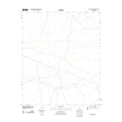
2011 Map of Smith Peak NE
USGS Topo · Published 2011About this map
Date Creek winds through this arid section of Yavapai County, where the desert landscape is defined by its seasonal watercourses and a sparse network of service roads. The geography is dominated by drainage patterns, with Bullard Wash and Miller Wash cutting across the southern half of the quadrangle. These natural features dictated the early paths of travel through the region, represented here by Wickenburg Rd and Alamo Rd. These routes provide essential access through the high desert, connecting this area of Arizona to larger thoroughfares while maintaining the isolated character of the basin. The topographical detail reveals the intricate erosion patterns and alluvial fans typical of the region's hydrography in the early twenty-first century.
Find a feature on this map
6 named features on this map. Tap any name to fly to it.
Don’t see what you’re looking for? This feature index may not catch every label — zoom into the map to look around manually.
Map Details
Editions of this 2011 Smith Peak NE Map
This is the sole edition of this map. No revisions or reprints were ever made.
Other maps of this area

1923 · Signal
USGS Topo · 1:250,000

1942 · Signal
USGS Topo · 1:250,000

1950 · Prescott
USGS Topo · 1:250,000

1954 · Prescott
USGS Topo · 1:250,000

1958 · Prescott
USGS Topo · 1:250,000

1959 · Prescott
USGS Topo · 1:250,000

1960 · Prescott
USGS Topo · 1:250,000

1965 · Prescott
USGS Topo · 1:250,000
1967 · Smith Peak
USGS Topo · 1:24,000
1967 · E.C.P. Peak
USGS Topo · 1:24,000