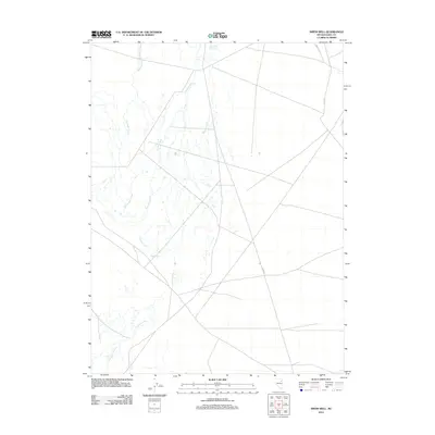
2012 Map of Smith Well
USGS Topo · Published 2012About this map
Smith Well serves as the central landmark in this high-desert portion of Elko County, where the hydrology of the Great Basin is on display. The braided paths of the Franklin River dominate the lowlands, fed by tributaries including Withington Creek and Warden Creek. To the north, the Ruby Valley Reservoir Number One anchors the drainage system in an area defined by wide basins and straight-line access roads. These transport routes, notably Butte Vly and the utilitarian Ccc Rd, reflect the logistical framework of managing this remote landscape. The map provides a clear view of the water distribution and desert infrastructure that supports life and industry in the Ruby Valley region.
Find a feature on this map
7 named features on this map. Tap any name to fly to it.
Don’t see what you’re looking for? This feature index may not catch every label — zoom into the map to look around manually.
Map Details
Editions of this 2012 Smith Well Map
This is the sole edition of this map. No revisions or reprints were ever made.
Other maps of this area

1935 · Halleck
USGS Topo · 1:125,000

1955 · Elko
USGS Topo · 1:250,000

1958 · Elko
USGS Topo · 1:250,000

1962 · Elko
USGS Topo · 1:250,000

1962 · Lamoille
USGS Topo · 1:62,500

1965 · Elko
USGS Topo · 1:250,000

1968 · Franklin Lake NE
USGS Topo · 1:24,000
1984 · Arizona Spring
USGS Topo · 1:24,000
1984 · Ruby City Creek
USGS Topo · 1:24,000

1984 · West of Delcer Buttes
USGS Topo · 1:24,000