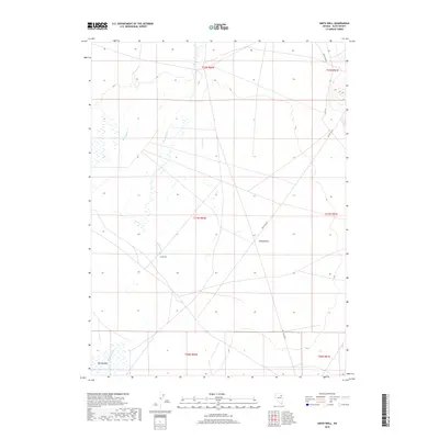
2018 Map of Smith Well
USGS Topo · Published 2018About this map
Franklin River meanders across this high desert landscape, defining the hydrological character of the western portion of Butte Valley. The map highlights a remote ranching and grazing environment where water sources are the primary landmarks for navigation and settlement. The eponymous Smith Well sits near the river's path, while the southern reaches open into the grassy expanse of Big Meadow. The presence of the CCC Rd suggests a period of infrastructure development by the Civilian Conservation Corps, likely aimed at managing these interior rangelands. Further east, the small settlement of Ruby Valley provides a human anchor in a terrain otherwise marked by ephemeral drainages like Warden Cr and Withington Cr. This survey documents a critical intersection of natural water systems and early twentieth-century land management efforts in Elko County.
Find a feature on this map
14 named features on this map. Tap any name to fly to it.
Don’t see what you’re looking for? This feature index may not catch every label — zoom into the map to look around manually.
Map Details
Editions of this 2018 Smith Well Map
This is the sole edition of this map. No revisions or reprints were ever made.
Other maps of this area

1935 · Halleck
USGS Topo · 1:125,000

1955 · Elko
USGS Topo · 1:250,000

1958 · Elko
USGS Topo · 1:250,000

1962 · Elko
USGS Topo · 1:250,000

1962 · Lamoille
USGS Topo · 1:62,500

1965 · Elko
USGS Topo · 1:250,000

1968 · Franklin Lake NE
USGS Topo · 1:24,000
1984 · Arizona Spring
USGS Topo · 1:24,000
1984 · Ruby City Creek
USGS Topo · 1:24,000

1984 · West of Delcer Buttes
USGS Topo · 1:24,000