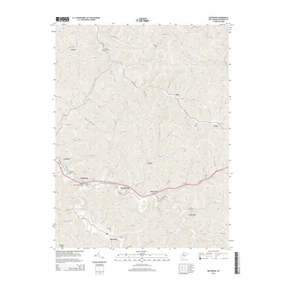
2014 Map of Smithburg
USGS Topo · Published 2014About this map
Smithburg and the surrounding Doddridge County countryside are defined by a complex network of narrow hollows and winding creek bottoms. Following the path of Buckeye Creek and Meathouse Fork, the landscape is dotted with small rural communities like Morgansville, Sherwood, and Blandville. The map reveals a dense distribution of family and community burial grounds, including Chestnut Grove Cem to the north and the Archbold Cem near the General John Craddock Bridge. This settlement pattern reflects a deeply rooted Appalachian geography where homes and infrastructure hug the valley floors beneath high ridges like Maxwell Ridge. Transportation is anchored by the corridor of Us-50 and Old US-50, which connect these dispersed settlements through the rugged interior. Numerous smaller hamlets such as Flint, Doak, and Avondale appear as quiet clusters along the tributary runs.
Find a feature on this map
100 named features on this map. Tap any name to fly to it.
Don’t see what you’re looking for? This feature index may not catch every label — zoom into the map to look around manually.
Map Details
Editions of this 2014 Smithburg Map
This is the sole edition of this map. No revisions or reprints were ever made.
Other maps of this area

1904 · Vadis
USGS Topo · 1:62,500

1905 · Centerpoint
USGS Topo · 1:62,500

1905 · West Union
USGS Topo · 1:62,500

1906 · Holbrook
USGS Topo · 1:62,500

1924 · Centerpoint
USGS Topo · 1:62,500

1924 · West Union
USGS Topo · 1:62,500

1924 · Holbrook
USGS Topo · 1:62,500

1925 · Centerpoint
USGS Topo · 1:62,500

1925 · Vadis
USGS Topo · 1:62,500

1926 · Holbrook
USGS Topo · 1:62,500