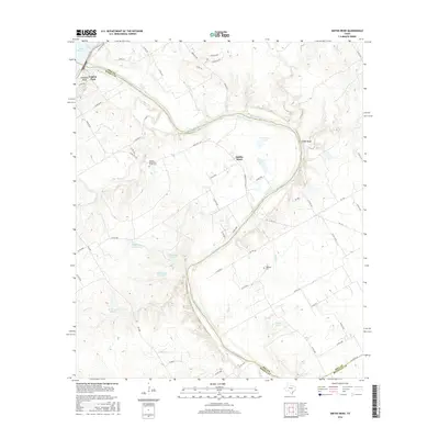
2016 Map of Smiths Bend
USGS Topo · Published 2016About this map
The Brazos River creates a prominent winding corridor through this landscape, separating the rugged banks of Chalk Bluff from the lower elevation floodplain at Smiths Bend. This era shows a mix of recreational and agricultural land use, anchored by the southeastern tip of Lake Whitney near Laguna Park and Sosebees Bluff. The terrain is deeply incised by numerous tributaries, including Coon Cr and Snake Cr, which feed into the main river channel. Local history is preserved in sites like the Smiths Bend-Coon Creek Cem and Lebanon Cem, providing critical points of reference for genealogists. The map also reveals a complex system of private and farm-to-market roads, such as FM 2114, and several private water features including G J Roberts Lake and the series of numbered K Bar Lake Number 1 reservoirs.
Find a feature on this map
65 named features on this map. Tap any name to fly to it.
Don’t see what you’re looking for? This feature index may not catch every label — zoom into the map to look around manually.
Map Details
Editions of this 2016 Smiths Bend Map
This is the sole edition of this map. No revisions or reprints were ever made.
Other maps of this area

1892 · Waco
USGS Topo · 1:125,000

1920 · Waco
USGS Topo · 1:125,000

1924 · Waco 2-b
USGS Topo · 1:48,000

1931 · Whitney
USGS Topo · 1:62,500

1931 · Valley Mills
USGS Topo · 1:62,500

1931 · Elm Mott
USGS Topo · 1:62,500

1954 · Waco
USGS Topo · 1:250,000

1955 · Waco
USGS Topo · 1:250,000
1957 · Aquilla
USGS Topo · 1:24,000
1957 · Peoria
USGS Topo · 1:24,000