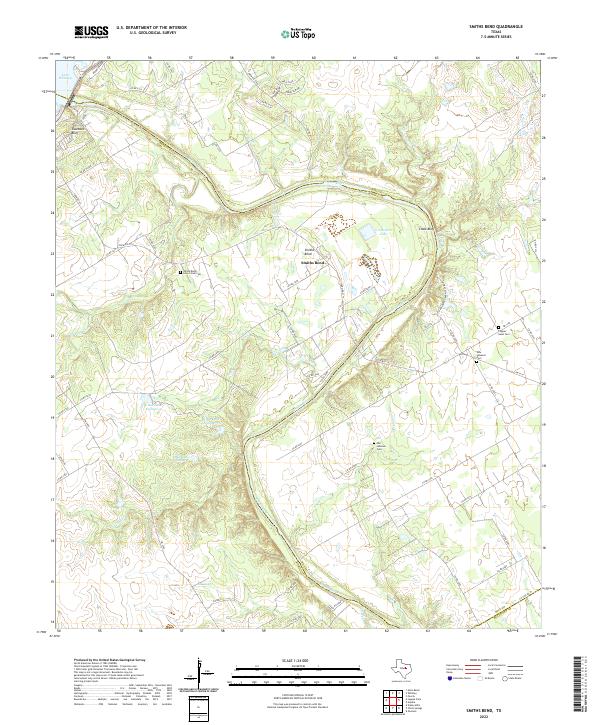
2022 Map of Smiths Bend
USGS Topo · Published 2022About this map
The Brazos River carves a dramatic winding path through the borderlands of Bosque and Hill Counties, creating the prominent loop of Smiths Bend. This rural landscape is defined by its series of upland plateaus and deep-cut creek drainages, including Snake Cr and Coon Cr. Evidence of early settlement is preserved in the numerous family and community burial grounds scattered across the terrain, notably the Smiths Bend - Coon Creek Cem and the distinct Old Lebanon Cem and New Lebanon Cem. To the northwest, the river widens into Lake Whitney near Sosebees Bluff, while downstream, the geology is revealed at Chalk Bluff. The map also details several smaller impoundments like G J Roberts Lake and the series of numbered lakes including K Bar Lake Number 4.
Find a feature on this map
70 named features on this map. Tap any name to fly to it.
Don’t see what you’re looking for? This feature index may not catch every label — zoom into the map to look around manually.
Map Details
Editions of this 2022 Smiths Bend Map
This is the sole edition of this map. No revisions or reprints were ever made.
Other maps of this area

1892 · Waco
USGS Topo · 1:125,000

1920 · Waco
USGS Topo · 1:125,000

1924 · Waco 2-b
USGS Topo · 1:48,000

1931 · Whitney
USGS Topo · 1:62,500

1931 · Valley Mills
USGS Topo · 1:62,500

1931 · Elm Mott
USGS Topo · 1:62,500

1954 · Waco
USGS Topo · 1:250,000

1955 · Waco
USGS Topo · 1:250,000
1957 · Aquilla
USGS Topo · 1:24,000
1957 · Peoria
USGS Topo · 1:24,000