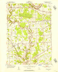
1952 Map of Smiths Creek
USGS Topo · Published 1954About this map
Kimball and St Clair townships are defined by a complex drainage network feeding the Black River and Pine River during the early 1950s. The settlement at Smiths Creek serves as a primary hub for this rural landscape, which is heavily marked by a high density of country schools like McCormick Sch and Pine River Sch. An interesting detail for local historians is the Canada Settlement Sch (Abandoned), which indicates a shifting population pattern in the township of Columbus even before the mid-century revision. Transportation is anchored by the Chesapeake and Ohio railroad corridor and the St Clair Airport, while local genealogy is rooted in sites such as St Marys Cem and the Israel Ch. The map's intricate depiction of drains like Mallory Drain and Slaght Drain illustrates the intensive land management required for the region's agricultural development.
Find a feature on this map
50 named features on this map. Tap any name to fly to it.
Don’t see what you’re looking for? This feature index may not catch every label — zoom into the map to look around manually.
Map Details
Editions of this 1952 Smiths Creek Map
2 editions found
Other maps of this area

1912 · Port Huron
USGS Topo · 1:62,500

1928 · Hicky
USGS Topo · 1:62,500

1929 · Port Huron
USGS Topo · 1:62,500

1936 · St. Clair
USGS Topo · 1:31,680

1936 · Rattle Run
USGS Topo · 1:31,680

1939 · Adair
USGS Topo · 1:24,000

1939 · Port Huron
USGS Topo · 1:24,000

1939 · St. Clair
USGS Topo · 1:24,000

1939 · Smiths Creek
USGS Topo · 1:24,000

1939 · Goodells
USGS Topo · 1:24,000