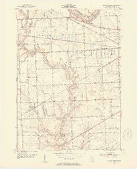
1952 Map of Smiths Creek
USGS Topo · Published 1954About this map
Smiths Creek sits at a rail junction in the early 1950s, serving as a focal point for the rural landscape of St. Clair County. The map details a transition from traditional agrarian settlements to early suburban growth, seen in pockets like Sparlingville and Edison Heights. The region is crisscrossed by the Chesapeake and Ohio RR and the Grand Trunk RR, which historically defined the industrial and transport movement between local hubs.
Find a feature on this map
68 named features on this map. Tap any name to fly to it.
Don’t see what you’re looking for? This feature index may not catch every label — zoom into the map to look around manually.
Map Details
Editions of this 1952 Smiths Creek Map
2 editions found
Other maps of this area

1912 · Port Huron
USGS Topo · 1:62,500

1928 · Hicky
USGS Topo · 1:62,500

1929 · Port Huron
USGS Topo · 1:62,500

1936 · St. Clair
USGS Topo · 1:31,680

1936 · Rattle Run
USGS Topo · 1:31,680

1939 · Adair
USGS Topo · 1:24,000

1939 · Port Huron
USGS Topo · 1:24,000

1939 · St. Clair
USGS Topo · 1:24,000

1939 · Smiths Creek
USGS Topo · 1:24,000

1939 · Goodells
USGS Topo · 1:24,000
Featured Places
- Marysville, MI
- Kimball, Kimball Township
- West Tappan, Kimball Township
- Columbus Township, MI
- Smiths Creek, Kimball Township