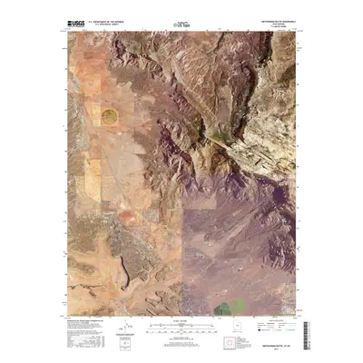
2017 Map of Smithsonian Butte
USGS Topo · Published 2017About this map
Smithsonian Butte and the Vermilion Cliffs dominate the center of this 2017 survey, where the high plateaus of southern Utah meet the Arizona border. The landscape is defined by massive geologic features like Canaan Mtn and Moccasin Terrace, punctuated by seasonal drainages such as Gould Wash and Grafton Wash. Human settlement is concentrated in the northern corridor at Rockville and in the south at Hildale, while Big Plain Junction serves as a connector between these remote outposts. Traces of historical land use appear through named water sources like Sawmill Spring and Canaan Springs, which were vital for life in this arid environment. Roads like Canaan Ranch Rd and Mesa Road skirt the base of the cliffs, providing the only access through the difficult terrain of the Big Plain and Dutton Pass.
Find a feature on this map
48 named features on this map. Tap any name to fly to it.
Don’t see what you’re looking for? This feature index may not catch every label — zoom into the map to look around manually.
Map Details
Editions of this 2017 Smithsonian Butte Map
This is the sole edition of this map. No revisions or reprints were ever made.
Other maps of this area

1885 · St. George
USGS Topo · 1:250,000

1886 · Kanab
USGS Topo · 1:250,000

1886 · Mt. Trumbull
USGS Topo · 1:250,000

1886 · Kaibab
USGS Topo · 1:250,000

1891 · St. George
USGS Topo · 1:250,000

1892 · Mt. Trumbull
USGS Topo · 1:250,000

1953 · Cedar City
USGS Topo · 1:250,000

1953 · Grand Canyon
USGS Topo · 1:250,000

1954 · La Verkin 4 SE
USGS Topo · 1:24,000

1954 · La Verkin 4 NW
USGS Topo · 1:24,000