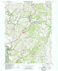
1994 Map of Smithton
USGS Topo · Published 1994About this map
Sewickley Creek and its many tributaries, including Hunters Run and Painters Run, define the rolling landscape of southwestern Westmoreland County. The 1990s character of this region is shaped by the intersection of traditional crossroads settlements and major transportation corridors. The Pennsylvania Turnpike cuts through the center of the map, marked by several key access points like Interchange 25A and Interchange 25B.
Find a feature on this map
54 named features on this map. Tap any name to fly to it.
Don’t see what you’re looking for? This feature index may not catch every label — zoom into the map to look around manually.
Map Details
Editions of this 1994 Smithton Map
This is the sole edition of this map. No revisions or reprints were ever made.
Other maps of this area

1902 · Brownsville
USGS Topo · 1:62,500

1902 · Connellsville
USGS Topo · 1:62,500

1904 · Mc Keesport
USGS Topo · 1:62,500

1904 · Greensburg
USGS Topo · 1:62,500

1906 · Brownsville
USGS Topo · 1:62,500

1906 · Greensburg
USGS Topo · 1:62,500

1907 · Pittsburg
USGS Topo · 1:62,500

1931 · Brownsville
USGS Topo · 1:62,500

1931 · Connellsville
USGS Topo · 1:62,500

1933 · Brownsville
USGS Topo · 1:62,500