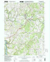
1997 Map of Smithton
USGS Topo · Published 2000About this map
The Youghiogheny River carves the southwestern corner of this landscape, anchoring the borough of Smithton. As the century draws to a close, the area maintains its mix of tight-knit settlements and rugged valley topography across South Huntingdon and Sewickley townships. The infrastructure of the Pennsylvania Turnpike Toll Road and several major interchanges, such as Interchange 25A near Waltz Mill, signal the modernization of this Westmoreland County corridor.
Find a feature on this map
51 named features on this map. Tap any name to fly to it.
Don’t see what you’re looking for? This feature index may not catch every label — zoom into the map to look around manually.
Map Details
Editions of this 1997 Smithton Map
This is the sole edition of this map. No revisions or reprints were ever made.
Other maps of this area

1902 · Brownsville
USGS Topo · 1:62,500

1902 · Connellsville
USGS Topo · 1:62,500

1904 · Mc Keesport
USGS Topo · 1:62,500

1904 · Greensburg
USGS Topo · 1:62,500

1906 · Brownsville
USGS Topo · 1:62,500

1906 · Greensburg
USGS Topo · 1:62,500

1907 · Pittsburg
USGS Topo · 1:62,500

1931 · Brownsville
USGS Topo · 1:62,500

1931 · Connellsville
USGS Topo · 1:62,500

1933 · Brownsville
USGS Topo · 1:62,500