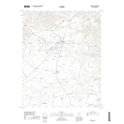
2019 Map of Smithville
USGS Topo · Published 2019About this map
Smithville serves as the central hub for this portion of DeKalb County, where state and local routes converge near the Smithville Municipal Airport. The landscape is defined by the branching tributaries of Pine Creek, Eagle Cr, and Holmes Cr, creating a series of ridges and hollows such as Fuston Hollow to the northwest. This area is notably dense with family and community burial grounds, offering significant value for genealogical research. Prominent sites include the DeKalb County Memorial Gardens and Whorton Springs Cem south of the main town center, along with numerous smaller plots like Baker Cem in Philippi and Adcock Cem near Midway. To the southwest, the terrain transitions toward Blue Springs, while the eastern edge is marked by the small settlement of Keltonburg near Sink Creek. The distribution of these named cemeteries and small communities like Snows Hill reflects a long-established rural settlement pattern that persists alongside modern aviation and highway infrastructure.
Find a feature on this map
163 named features on this map. Tap any name to fly to it.
Don’t see what you’re looking for? This feature index may not catch every label — zoom into the map to look around manually.
Map Details
Editions of this 2019 Smithville Map
This is the sole edition of this map. No revisions or reprints were ever made.
Other maps of this area

1893 · Mc Minnville
USGS Topo · 1:125,000

1895 · Mc Minnville
USGS Topo · 1:125,000

1928 · Gordonsville
USGS Topo · 1:62,500

1942 · Statesville
USGS Topo · 1:100,000

1943 · Cookeville
USGS Topo · 1:100,000

1944 · Cookeville
USGS Topo · 1:100,000

1953 · Chattanooga
USGS Topo · 1:250,000

1956 · Silver Point
USGS Topo · 1:24,000

1956 · Corbin
USGS Topo · 1:250,000

1957 · Chattanooga
USGS Topo · 1:250,000