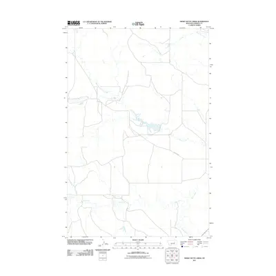
2011 Map of Smoky Butte Creek
USGS Topo · Published 2011About this map
Big Dry Creek and its complex network of seasonal tributaries define this expansive section of Garfield County. The landscape is characterized by the meandering path of Lone Tree Creek and its secondary branch, North Fork Lone Tree Creek, which drain toward a central catchment area. Human activity is focused around the settlement of Steve Forks, located in the southern portion of the quadrangle where multiple drainages converge. The primary terrestrial artery through this ranching country is Lone Tree Rd, which provides access across the northern terrain. This survey illustrates the intricate relationship between the region's scattered settlements and the essential watercourses like Smoky Butte Creek that dictate the patterns of land use in this part of Montana.
Find a feature on this map
6 named features on this map. Tap any name to fly to it.
Don’t see what you’re looking for? This feature index may not catch every label — zoom into the map to look around manually.
Map Details
Editions of this 2011 Smoky Butte Creek Map
This is the sole edition of this map. No revisions or reprints were ever made.
Other maps of this area

1954 · Jordan
USGS Topo · 1:250,000

1956 · Jordan
USGS Topo · 1:250,000

1958 · Jordan
USGS Topo · 1:250,000

1964 · Jordan
USGS Topo · 1:250,000

1965 · Big Dry School
USGS Topo · 1:24,000

1965 · Edwards
USGS Topo · 1:24,000

1965 · Ziegele Coulee
USGS Topo · 1:24,000
1983 · Biscuit Butte
USGS Topo · 1:24,000

1983 · Steve Forks
USGS Topo · 1:24,000
1983 · Smoky Butte
USGS Topo · 1:24,000