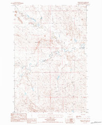
1983 Map of Smoky Butte
USGS Topo · Published 1984About this map
Smoky Butte dominates the northern reaches of this eastern Montana landscape, anchoring a terrain defined by the complex drainage systems of the Missouri River watershed. The map details the winding course of Big Dry Creek as it moves through the heart of the quadrangle, joined by smaller tributaries like Lone Tree Creek, Dry Creek, and Smoky Butte Creek. These seasonal watercourses reveal the underlying geology of the region, where erosion has carved intricate patterns into the plains. For genealogists and local historians, the Hintner Cem in the southeastern portion of the sheet provides a tangible link to the early ranching and homesteading families who settled this part of Garfield County. The sparse distribution of man-made landmarks and the reliance on unimproved roads emphasize the vast, open character of the Montana prairie in the early 1980s.
Find a feature on this map
6 named features on this map. Tap any name to fly to it.
Don’t see what you’re looking for? This feature index may not catch every label — zoom into the map to look around manually.
Map Details
Editions of this 1983 Smoky Butte Map
This is the sole edition of this map. No revisions or reprints were ever made.
Other maps of this area

1954 · Jordan
USGS Topo · 1:250,000

1956 · Jordan
USGS Topo · 1:250,000

1958 · Jordan
USGS Topo · 1:250,000

1964 · Jordan
USGS Topo · 1:250,000

1964 · Jordan NW
USGS Topo · 1:24,000

1964 · Jordan
USGS Topo · 1:24,000

1965 · Big Dry School
USGS Topo · 1:24,000

1965 · Darby Buttes
USGS Topo · 1:24,000

1965 · Ziegele Coulee
USGS Topo · 1:24,000
1983 · Jordan
USGS Topo · 1:100,000