
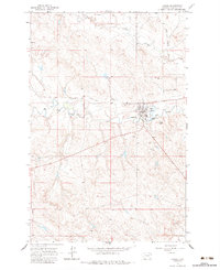
1964 Map of Jordan
USGS Topo · Published 1967About this map
The town of Jordan serves as the focal point of this 1964 survey, situated near the confluence of Big Dry Creek and several smaller drainages like Sand Cr. The community layout is captured in detail, showing the County Fairground, Woodland Park, and Panwitz Park bordering the residential grid. Local history is anchored at the Pioneer Cem on the edge of town and the Greenhedge Cem further north. This landscape reflects the ranching and agricultural life of Garfield County, where water management is visible through features like the Spillway Elev 2671 and the Sewage Disposal Pond. Transportation and infrastructure are represented by a local Landing Strip and a Radio Tower, while the surrounding terrain is defined by low coulees and the elevation at Pikes Peak.
Find a feature on this map
18 named features on this map. Tap any name to fly to it.
Don’t see what you’re looking for? This feature index may not catch every label — zoom into the map to look around manually.
Map Details
Editions of this 1964 Jordan Map
2 editions found
Other maps of this area

1954 · Jordan
USGS Topo · 1:250,000

1956 · Jordan
USGS Topo · 1:250,000

1958 · Jordan
USGS Topo · 1:250,000

1964 · Jordan
USGS Topo · 1:250,000

1964 · Jordan SE
USGS Topo · 1:24,000

1964 · Jordan NE
USGS Topo · 1:24,000

1964 · Jordan NW
USGS Topo · 1:24,000

1965 · Kirby Ranch
USGS Topo · 1:24,000

1965 · Darby Buttes
USGS Topo · 1:24,000

1965 · Ziegele Coulee
USGS Topo · 1:24,000