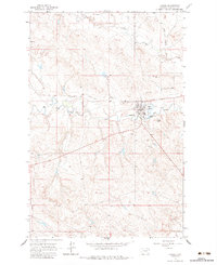
1964 Map of Jordan
USGS Topo · Published 1984About this map
Jordan stands as a vital hub in the vast Montana cattle country, its town grid established near the confluence of Big Dry Creek and Huff Coulee. This 1964 field-checked survey illustrates the essential infrastructure of a remote county seat, from the Landing Strip and County Fairground on the western outskirts to the specialized Sewage Disposal Pond and Radio Tower that supported mid-century growth. The landscape is defined by its drainage patterns, with intermittent streams like Vail Creek and Sand Cr carving through the terrain.
Find a feature on this map
17 named features on this map. Tap any name to fly to it.
Don’t see what you’re looking for? This feature index may not catch every label — zoom into the map to look around manually.
Map Details
Editions of this 1964 Jordan Map
2 editions found
Other maps of this area

1954 · Jordan
USGS Topo · 1:250,000

1956 · Jordan
USGS Topo · 1:250,000

1958 · Jordan
USGS Topo · 1:250,000

1964 · Jordan
USGS Topo · 1:250,000

1964 · Jordan SE
USGS Topo · 1:24,000

1964 · Jordan NE
USGS Topo · 1:24,000

1964 · Jordan NW
USGS Topo · 1:24,000

1964 · Jordan
USGS Topo · 1:24,000

1965 · Kirby Ranch
USGS Topo · 1:24,000

1965 · Darby Buttes
USGS Topo · 1:24,000