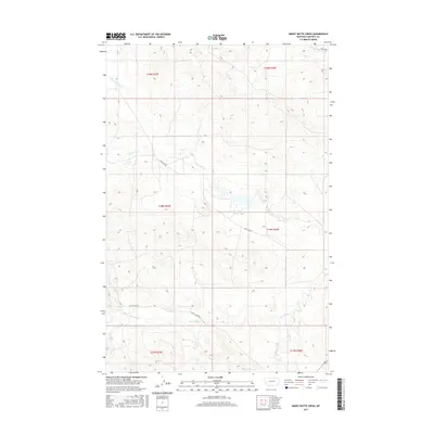
2017 Map of Smoky Butte Creek
USGS Topo · Published 2017About this map
Lone Tree Creek and its many seasonal tributaries define the landscape of this Garfield County interior, where the high prairie is dissected by a network of drainage basins. The area is characterized by vast tracts of public and private rangeland, crisscrossed only by isolated routes like Lone Tree Rd and Steve's Fork Rd. These roads provide rare access to the remote sections of the high plains, connecting the headwaters of Smoky Butte Creek in the north to the Steve Forks and Big Dry Creek systems in the south. The survey reveals a sparse settlement pattern dominated by the township and range system, showing the resilience required for agricultural and ranching life in this part of Montana. For those tracing the geography of the Big Dry country, the map documents the critical water sources and primitive tracks that have facilitated land use for generations.
Find a feature on this map
13 named features on this map. Tap any name to fly to it.
Don’t see what you’re looking for? This feature index may not catch every label — zoom into the map to look around manually.
Map Details
Editions of this 2017 Smoky Butte Creek Map
This is the sole edition of this map. No revisions or reprints were ever made.
Other maps of this area

1954 · Jordan
USGS Topo · 1:250,000

1956 · Jordan
USGS Topo · 1:250,000

1958 · Jordan
USGS Topo · 1:250,000

1964 · Jordan
USGS Topo · 1:250,000

1965 · Big Dry School
USGS Topo · 1:24,000

1965 · Edwards
USGS Topo · 1:24,000

1965 · Ziegele Coulee
USGS Topo · 1:24,000
1983 · Biscuit Butte
USGS Topo · 1:24,000

1983 · Steve Forks
USGS Topo · 1:24,000
1983 · Smoky Butte
USGS Topo · 1:24,000