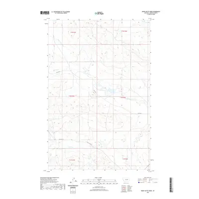
2020 Map of Smoky Butte Creek
USGS Topo · Published 2020About this map
Smoky Butte Creek and the headwaters of the Big Dry Creek system define this section of the Garfield County landscape. This remote ranching country is accessed primarily by unpaved routes such as Lone Tree Rd and Steve's Fork Rd, which traverse a terrain characterized by intermittent drainage networks. The map details the convergence of several small tributaries, including N Fork Lone Tree Creek and Lone Tree Creek, alongside the curiously named Steve Forks. These features illustrate the sparse but essential water resources that have historically dictated land use and property boundaries in this part of eastern Montana. The prevalence of named ephemeral creeks highlights the geographic significance of even the smallest seasonal flows in an otherwise arid environment.
Find a feature on this map
13 named features on this map. Tap any name to fly to it.
Don’t see what you’re looking for? This feature index may not catch every label — zoom into the map to look around manually.
Map Details
Editions of this 2020 Smoky Butte Creek Map
This is the sole edition of this map. No revisions or reprints were ever made.
Other maps of this area

1954 · Jordan
USGS Topo · 1:250,000

1956 · Jordan
USGS Topo · 1:250,000

1958 · Jordan
USGS Topo · 1:250,000

1964 · Jordan
USGS Topo · 1:250,000

1965 · Big Dry School
USGS Topo · 1:24,000

1965 · Edwards
USGS Topo · 1:24,000

1965 · Ziegele Coulee
USGS Topo · 1:24,000
1983 · Biscuit Butte
USGS Topo · 1:24,000

1983 · Steve Forks
USGS Topo · 1:24,000
1983 · Smoky Butte
USGS Topo · 1:24,000