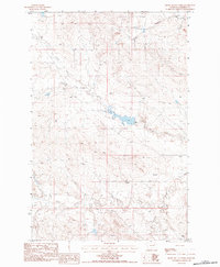
1983 Map of Smoky Butte Creek
USGS Topo · Published 1984About this map
Smoky Butte dominates the northeastern corner of this Montana landscape, overlooking a network of ephemeral watercourses and intricate topography. This 1983 provisional survey captures a sparsely populated region of Garfield County, defined by the winding paths of North Fork Lone Tree Creek and Lone Tree Creek. A significant Dam along the latter indicates managed water resources in an environment shaped by drainage systems like Steve Forks and Smoky Butte Creek. The map provides a detailed record of the terrain before later developments, showing the convergence of these creeks as they flow toward Big Dry Creek. The intricate contouring illustrates the complex erosional patterns typical of the Montana plains, highlighting how natural drainages dictated the early spatial organization of this territory.
Find a feature on this map
7 named features on this map. Tap any name to fly to it.
Don’t see what you’re looking for? This feature index may not catch every label — zoom into the map to look around manually.
Map Details
Editions of this 1983 Smoky Butte Creek Map
This is the sole edition of this map. No revisions or reprints were ever made.
Other maps of this area

1954 · Jordan
USGS Topo · 1:250,000

1956 · Jordan
USGS Topo · 1:250,000

1958 · Jordan
USGS Topo · 1:250,000

1964 · Jordan
USGS Topo · 1:250,000

1965 · Big Dry School
USGS Topo · 1:24,000

1965 · Edwards
USGS Topo · 1:24,000

1965 · Ziegele Coulee
USGS Topo · 1:24,000
1983 · Biscuit Butte
USGS Topo · 1:24,000

1983 · Steve Forks
USGS Topo · 1:24,000
1983 · Smoky Butte
USGS Topo · 1:24,000