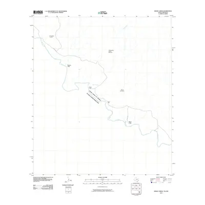
2010 Map of Smoky Creek
USGS Topo · Published 2010About this map
Buenos Aires and Sierra Chino mark the sparse human presence along this remote reach of the international border in Brewster County. The landscape is defined by the winding course of the Rio Grande, which separates the United States of America and Mexico. Dramatic geologic features dominate the terrain, including the sharp relief of Smugglers Canyon and the prominent Triangulation Station Mountain. The presence of Black Dike and the Sierra de Chino range suggests a complex volcanic and erosional history in this desert environment. Navigation through the area is largely limited to the path of River Rd W, which follows the river's northern bank. Small ephemeral drainage systems like Smoky Creek carve through the arid landscape, highlighting the importance of the primary river as the region's lifeblood.
Find a feature on this map
11 named features on this map. Tap any name to fly to it.
Don’t see what you’re looking for? This feature index may not catch every label — zoom into the map to look around manually.
Map Details
Editions of this 2010 Smoky Creek Map
This is the sole edition of this map. No revisions or reprints were ever made.
Other maps of this area

1903 · Chisos Mountains
USGS Topo · 1:125,000

1903 · Terlingua
USGS Topo · 1:125,000

1904 · Terlingua
USGS Topo · 1:125,000

1905 · Chisos Mountains
USGS Topo · 1:125,000

1959 · Emory Peak
USGS Topo · 1:250,000

1965 · Emory Peak
USGS Topo · 1:250,000

1971 · Cerro Castellan
USGS Topo · 1:24,000
1971 · Reed Camp
USGS Topo · 1:24,000
1971 · Castolon
USGS Topo · 1:24,000
1971 · Smoky Creek
USGS Topo · 1:24,000