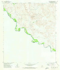
1971 Map of Smoky Creek
USGS Topo · Published 1974About this map
The Rio Grande carves a winding path through this desert landscape, forming the international boundary between the United States and Mexico. This portion of Big Bend National Park is defined by the sharp elevations of Triangulation Station Mountain and the craggy outcrops of the Sierra de Chino. While the area is dominated by natural landforms like Black Dike, evidence of human activity is scattered throughout the river valley. Sparse settlements and points of interest include Buenos Aires and the former Smoky Creek Site, alongside various unmarked ruins and a lone Cem near the riverbank. A series of Pack Trails and a Gaging Sta underscore the history of transport and water management in this remote stretch of Brewster County during the early 1970s.
Find a feature on this map
15 named features on this map. Tap any name to fly to it.
Don’t see what you’re looking for? This feature index may not catch every label — zoom into the map to look around manually.
Map Details
Editions of this 1971 Smoky Creek Map
This is the sole edition of this map. No revisions or reprints were ever made.
Other maps of this area

1903 · Chisos Mountains
USGS Topo · 1:125,000

1903 · Terlingua
USGS Topo · 1:125,000

1904 · Terlingua
USGS Topo · 1:125,000

1905 · Chisos Mountains
USGS Topo · 1:125,000

1959 · Emory Peak
USGS Topo · 1:250,000

1965 · Emory Peak
USGS Topo · 1:250,000

1971 · Cerro Castellan
USGS Topo · 1:24,000
1971 · Reed Camp
USGS Topo · 1:24,000
1971 · Castolon
USGS Topo · 1:24,000
1971 · Emory Peak
USGS Topo · 1:24,000