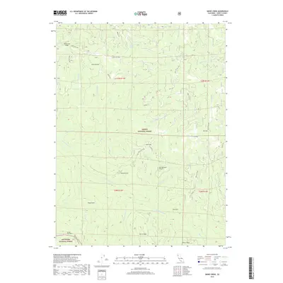
2018 Map of Smoky Creek
USGS Topo · Published 2018About this map
The South Fork Trinity River carves through this northern California landscape, forming the boundary between the Trinity National Forest and Six Rivers National Forest. This modern survey records the complex system of forest routes and ridge-top lookouts used for land management, such as Horse Ridge Lookout Rd and Bramlet Rd. Named grazing lands and water sources like Red Mountain Pasture, Swim Meadow, and Seven Up Cedars Spring speak to the area's legacy of high-country ranching and resource use. The topography is defined by high points like Red Mtn and South Fork Mtn, separated by deep drainages including Murphy Gulch and Dog Gulch. This map provides a detailed view of the watershed before it joins the larger Trinity river system, documenting a region dominated by timber and wilderness management.
Find a feature on this map
41 named features on this map. Tap any name to fly to it.
Don’t see what you’re looking for? This feature index may not catch every label — zoom into the map to look around manually.
Map Details
Editions of this 2018 Smoky Creek Map
This is the sole edition of this map. No revisions or reprints were ever made.
Other maps of this area

1918 · Anada
USGS Topo · 1:62,500

1921 · Hoaglin
USGS Topo · 1:62,500

1922 · Island Mountain
USGS Topo · 1:62,500

1931 · Hoaglin
USGS Topo · 1:96,000

1935 · Hoaglin
USGS Topo · 1:125,000

1953 · Blackrock Mtn
USGS Topo · 1:62,500

1954 · Pickett Peak
USGS Topo · 1:62,500

1954 · Dubakella Mtn
USGS Topo · 1:62,500

1954 · Blackrock Mtn
USGS Topo · 1:62,500
1955 · Kettenpom
USGS Topo · 1:62,500