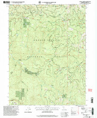
1998 Map of Smoky Creek
USGS Topo · Published 2003About this map
Murphy Place, St Jacques Place, and Bramlet Place occupy the wooded slopes and river bends of this late twentieth-century forest survey. The landscape is defined by the convergence of major watersheds, where the South Fork Mad River meets the southern boundaries and the Trinity River winds through the Hayfork Yolla Bolla District. This environment supported localized homesteads and high-elevation campsites like Pose Camp and Swim Meadow, connected by the winding Bramlet Road. Grounded in data from 1981 and revised in 1998, the map illustrates the complex drainage network of Smoky Creek and its many tributaries, such as Silver Spring Creek and Happy Camp Creek. The area within the Shasta-Trinity National Forests remains a mosaic of steep ridges including Rattlesnake Ridge and Wilcox Ridge, providing a detailed look at the geography before modern forest management changes.
Find a feature on this map
36 named features on this map. Tap any name to fly to it.
Don’t see what you’re looking for? This feature index may not catch every label — zoom into the map to look around manually.
Map Details
Editions of this 1998 Smoky Creek Map
This is the sole edition of this map. No revisions or reprints were ever made.
Other maps of this area

1918 · Anada
USGS Topo · 1:62,500

1921 · Hoaglin
USGS Topo · 1:62,500

1922 · Island Mountain
USGS Topo · 1:62,500

1931 · Hoaglin
USGS Topo · 1:96,000

1935 · Hoaglin
USGS Topo · 1:125,000

1953 · Blackrock Mtn
USGS Topo · 1:62,500

1954 · Pickett Peak
USGS Topo · 1:62,500

1954 · Dubakella Mtn
USGS Topo · 1:62,500

1954 · Blackrock Mtn
USGS Topo · 1:62,500
1955 · Kettenpom
USGS Topo · 1:62,500