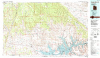
1985 Map of Smoky Mountain
USGS Topo · Published 1985About this map
Lake Powell dominates the southern landscape of this 1985 survey, its finger-like bays such as Rock Creek Bay and Last Chance Bay reaching deep into the canyons of the Colorado River system. The high desert plateaus of the Kaiparowits Plateau and Smoky Mountain rise to the north, defined by dramatic geological features like the Straight Cliffs and the sweeping arc of Fiftymile Mountain. This era shows the region after the completion of the Glen Canyon Dam, when the rising waters had already transformed the deep sandstone gorges into a complex reservoir system.
Find a feature on this map
46 named features on this map. Tap any name to fly to it.
Don’t see what you’re looking for? This feature index may not catch every label — zoom into the map to look around manually.
Map Details
Editions of this 1985 Smoky Mountain Map
2 editions found
Other maps of this area

1883 · Marsh Pass
USGS Topo · 1:250,000

1886 · Kanab
USGS Topo · 1:250,000

1886 · Escalante
USGS Topo · 1:250,000

1886 · Henry Mountains
USGS Topo · 1:250,000

1886 · Echo Cliffs
USGS Topo · 1:250,000

1886 · Kaibab
USGS Topo · 1:250,000

1891 · Echo Cliffs
USGS Topo · 1:250,000

1892 · Marsh Pass
USGS Topo · 1:250,000

1892 · Henry Mountains
USGS Topo · 1:250,000

1922 · Warm Creek
USGS Topo · 1:63,360