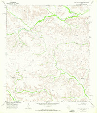
1969 Map of Smoky Mountain Ranch
USGS Topo · Published 1972About this map
Smoky Mountain Ranch and Slaughter anchor this West Texas landscape along the high plateau of the Edwards Plateau region, where the Pecos Co Terrell Co boundary line divides the arid terrain. The map documents an area defined by deep drainage networks and isolated ranching outposts in the late 1960s. Significant watercourses like Lower Fourmile Draw and Sheffield Draw carve through the limestone, leading toward the dramatic descent of Surveyor Canyon. Industrial activity is evident in the northern reaches, where an Oil Field and scattered Drill Holes indicate the expansion of petroleum exploration into these remote ranchlands. A dedicated Landing Area near the main ranch complex and a network of Jeep Trails illustrate the era's reliance on specialized transport to navigate the expansive draws and ridges surrounding Smoky Mountain.
Find a feature on this map
11 named features on this map. Tap any name to fly to it.
Don’t see what you’re looking for? This feature index may not catch every label — zoom into the map to look around manually.
Map Details
Editions of this 1969 Smoky Mountain Ranch Map
This is the sole edition of this map. No revisions or reprints were ever made.
Other maps of this area

1929 · Sheffield
USGS Topo · 1:125,000

1929 · Independence Draw Quadrangle
USGS Topo · 1:125,000

1954 · Fort Stockton
USGS Topo · 1:250,000

1954 · Sonora
USGS Topo · 1:250,000

1958 · Sonora
USGS Topo · 1:250,000

1958 · Fort Stockton
USGS Topo · 1:250,000

1967 · Divide Country
USGS Topo · 1:24,000

1967 · Sheffield NW
USGS Topo · 1:24,000

1967 · Horsehead Canyon
USGS Topo · 1:24,000
1969 · Mitchell Draw
USGS Topo · 1:24,000