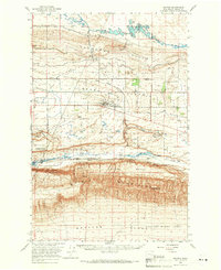
1965 Map of Smyrna
USGS Topo · Published 1966About this map
Royal City and the surrounding irrigation developments of the mid-1960s define this landscape in Grant County. The map documents the extensive water management systems of the Columbia Basin Project, including the West Canal, Frenchman Hills Wasteway, and the Crab Creek Lateral which transformed the Royal Slope into a productive agricultural region. This infrastructure stands in contrast to the southern terrain, where the Saddle Mountains rise to Wahatis Peak above the Smyrna Bench. Along the base of these heights, the Chicago Milwaukee St Paul and Pacific railroad tracks follow the course of Lower Crab Creek past the settlement of Smyrna. The southern edge of the map identifies the perimeter of the Hanford Works (A E C), while the central portion is dominated by the Columbia National Wildlife Refuge, showcasing a complex mix of federal land use, industrial history, and wildlife preservation.
Find a feature on this map
41 named features on this map. Tap any name to fly to it.
Don’t see what you’re looking for? This feature index may not catch every label — zoom into the map to look around manually.
Map Details
Editions of this 1965 Smyrna Map
This is the sole edition of this map. No revisions or reprints were ever made.
Other maps of this area

1909 · Quincy
USGS Topo · 1:62,500

1910 · Quincy
USGS Topo · 1:62,500

1910 · Winchester
USGS Topo · 1:62,500

1911 · Red Rock
USGS Topo · 1:62,500

1912 · Moses Lake
USGS Topo · 1:62,500

1912 · Beverly
USGS Topo · 1:62,500

1916 · Coyote Rapids
USGS Topo · 1:62,500

1917 · Priest Rapids
USGS Topo · 1:62,500

1923 · Corfu
USGS Topo · 1:62,500

1924 · Hanford
USGS Topo · 1:62,500