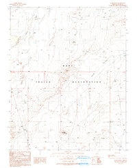
1991 Map of Snake Butte
USGS Topo · Published 1991About this map
The Hopi Indian Reservation landscape is defined by its arid drainage systems and prominent geological formations. This 1991 provisional survey captures a territory where seasonal water management is critical, evidenced by numerous Check Dams and Water Tanks scattered across the high desert. Prominent landmarks such as Snake Butte and Red Needle rise above the surrounding terrain, providing essential navigational markers in an area with few paved roads. The ephemeral Polacca Wash and Talahogan Wash underscore the hydrologic patterns of the region, while isolated features like a Prospect and several corrals indicate historical land use tied to mineral exploration and livestock. This map records the intersection of traditional land holdings and the necessary infrastructure for surviving in the arid Southwest during the late twentieth century.
Find a feature on this map
14 named features on this map. Tap any name to fly to it.
Don’t see what you’re looking for? This feature index may not catch every label — zoom into the map to look around manually.
Map Details
Editions of this 1991 Snake Butte Map
This is the sole edition of this map. No revisions or reprints were ever made.
Other maps of this area

1883 · Tusayan
USGS Topo · 1:250,000

1886 · Tusayan
USGS Topo · 1:250,000

1947 · Flagstaff
USGS Topo · 1:250,000

1954 · Flagstaff
USGS Topo · 1:250,000

1958 · Flagstaff
USGS Topo · 1:250,000

1960 · Flagstaff
USGS Topo · 1:250,000

1962 · Flagstaff
USGS Topo · 1:250,000

1966 · Oraibi
USGS Topo · 1:62,500

1966 · Egloffstein Butte
USGS Topo · 1:62,500

1966 · Tovar Mesa
USGS Topo · 1:62,500