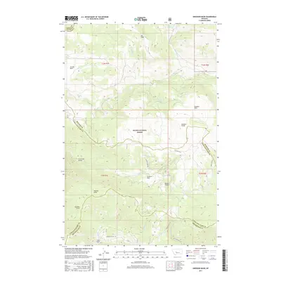
2017 Map of Snedaker Basin
USGS Topo · Published 2017About this map
The Helena National Forest encompasses this high-altitude landscape where three Montana counties—Meagher, Lewis and Clark, and Broadwater—meet. This 2017 survey reveals a terrain defined by dramatic vertical relief and complex drainage patterns, where steep ridgelines like Elk Ridge separate high basins from deep canyons. The central Snedaker Divide acts as a topographical spine, shedding water into distinct catchments such as the Snedaker Basin and Jim Ball Basin. Notable landmarks such as Vigilante Gulch and Hanging Valley suggest a geologic history carved by water and ice. Access to this remote wilderness is maintained through a network of forest routes, including Sunshine Basin Rd and Magpie Gulch Rd, which follow the natural contours of the land toward lower elevations like Trout Creek Canyon.
Find a feature on this map
24 named features on this map. Tap any name to fly to it.
Don’t see what you’re looking for? This feature index may not catch every label — zoom into the map to look around manually.
Map Details
Editions of this 2017 Snedaker Basin Map
This is the sole edition of this map. No revisions or reprints were ever made.
Other maps of this area

1886 · Fort Logan
USGS Topo · 1:250,000

1948 · White Sulphur Springs
USGS Topo · 1:250,000

1950 · Canyon Ferry
USGS Topo · 1:62,500

1958 · White Sulphur Springs
USGS Topo · 1:250,000

1961 · White Sulphur Springs
USGS Topo · 1:250,000

1962 · Hogback Mountain
USGS Topo · 1:24,000

1962 · B K Ranch
USGS Topo · 1:24,000
1962 · Middle Creek Lake
USGS Topo · 1:24,000

1962 · Snedaker Basin
USGS Topo · 1:24,000

1965 · White Sulphur Springs
USGS Topo · 1:250,000
Featured Places
- Vigilante Overlook, MT
- Lewis and Clark County, MT
- Broadwater County, MT
- Meagher County, MT
- United States