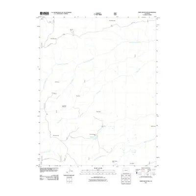
2011 Map of Snipe Mountain
USGS Topo · Published 2011About this map
Snipe Mountain and the surrounding high country of Mesa County define this landscape of ridges and ranching outposts. The map documents several seasonal livestock stations, including Blumberg Camp in the north and Musser Cow Camp near Points Creek. Water management for this arid terrain is evidenced by the Beaver-Huffington Dam and its accompanying Beaver Dam Reservoir situated below Kelso Mesa. The drainage system is intricate, with the North Fork Escalante Creek and Middle Fork Escalante Creek carving deep paths across the territory. Notable landmarks such as Long Point Mountain and Monument Hill provide essential orientation points for those navigating the Divide Rd and the Brushy Ridge Trl.
Find a feature on this map
26 named features on this map. Tap any name to fly to it.
Don’t see what you’re looking for? This feature index may not catch every label — zoom into the map to look around manually.
Map Details
Editions of this 2011 Snipe Mountain Map
This is the sole edition of this map. No revisions or reprints were ever made.
Other maps of this area

1916 · Paradox Valley
USGS Topo · 1:125,000

1922 · Paradox Valley
USGS Topo · 1:125,000

1949 · Atkinson Creek
USGS Topo · 1:24,000

1950 · Atkinson Creek
USGS Topo · 1:24,000

1956 · Moab
USGS Topo · 1:250,000

1959 · Moab
USGS Topo · 1:250,000

1960 · Moab
USGS Topo · 1:250,000
1960 · Atkinson Creek
USGS Topo · 1:24,000
1960 · Nucla
USGS Topo · 1:62,500
1960 · Windy Point
USGS Topo · 1:24,000