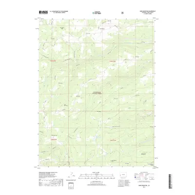
2019 Map of Snipe Mountain
USGS Topo · Published 2019About this map
The Uncompahgre National Forest dominates this high-altitude landscape of the Uncompahgre Plateau, where a complex system of drainage and mesas defines the terrain. The map details the transition between high peaks like Snipe Mtn and Brush Mtn and the broad, flat expanses of Kelso Mesa and the North Loyd Mesa Bench. Water management in this arid environment is highlighted by the Beaver Dam Reservoir, which sits at the head of a network of canyons carved by Kelso Cr and the N Fork Escalante Cr. Historical land use is visible through references to old livestock areas like Indian Park and the Atkinson Bench. The presence of Monument Hill and the Musser trail provides specific points of interest for navigating the ridges and draws of this protected wilderness area.
Find a feature on this map
41 named features on this map. Tap any name to fly to it.
Don’t see what you’re looking for? This feature index may not catch every label — zoom into the map to look around manually.
Map Details
Editions of this 2019 Snipe Mountain Map
This is the sole edition of this map. No revisions or reprints were ever made.
Other maps of this area

1916 · Paradox Valley
USGS Topo · 1:125,000

1922 · Paradox Valley
USGS Topo · 1:125,000

1949 · Atkinson Creek
USGS Topo · 1:24,000

1950 · Atkinson Creek
USGS Topo · 1:24,000

1956 · Moab
USGS Topo · 1:250,000

1959 · Moab
USGS Topo · 1:250,000

1960 · Moab
USGS Topo · 1:250,000
1960 · Atkinson Creek
USGS Topo · 1:24,000
1960 · Nucla
USGS Topo · 1:62,500
1960 · Windy Point
USGS Topo · 1:24,000