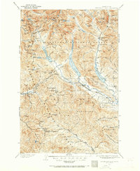
1901 Map of Snoqualmie Pass
USGS Topo · Published 1965About this map
Keechelus Lake and Kachess Lake dominate this high-altitude survey of the Cascades, capturing the region as it transitioned into a vital transportation corridor at the start of the 20th century. The Northern Pacific Railway winds through the mountains, anchored by the engineering feat of the Stampede Tunnel, which allowed rail traffic to bypass the highest ridges. Settlements like Easton, Ronald, and Lester appear as small hubs defined by their proximity to the tracks and the logging and mining potential of the surrounding Wenatchee National Forest.
Find a feature on this map
151 named features on this map. Tap any name to fly to it.
Don’t see what you’re looking for? This feature index may not catch every label — zoom into the map to look around manually.
Map Details
Editions of this 1901 Snoqualmie Pass Map
2 editions found
Other maps of this area

1897 · Mount Stuart
USGS Topo · 1:125,000

1899 · Ellensburg
USGS Topo · 1:125,000

1901 · Ellensburg
USGS Topo · 1:125,000

1901 · Chiwaukum
USGS Topo · 1:125,000

1901 · Snoqualmie Pass
USGS Topo · 1:125,000

1902 · Mount Aix
USGS Topo · 1:125,000

1902 · Skykomish
USGS Topo · 1:125,000

1902 · Mount Stuart
USGS Topo · 1:125,000

1903 · Snoqualmie
USGS Topo · 1:125,000

1904 · Mt Aix
USGS Topo · 1:125,000