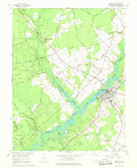
1966 Map of Snow Hill
USGS Topo · Published 1968About this map
The Pocomoke River defines the landscape of central Worcester County, where the town of Snow Hill serves as a historic hub at the crossing of the Pennsylvania Central railroad. This mid-1960s survey illustrates a region shaped by its waterways and timberlands, with the Pocomoke State Forest and Shad Landing State Park preserving large tracts of the river's eastern banks. Smaller settlements and landings such as Millville, Corbin, and Milburn Landing are connected by a network of rural routes like Old Furnace Road and Disharoon Road.
Find a feature on this map
62 named features on this map. Tap any name to fly to it.
Don’t see what you’re looking for? This feature index may not catch every label — zoom into the map to look around manually.
Map Details
Editions of this 1966 Snow Hill Map
2 editions found
Other maps of this area

1901 · Snow Hill
USGS Topo · 1:62,500

1901 · Salisbury
USGS Topo · 1:62,500

1902 · Pittsville
USGS Topo · 1:62,500

1942 · Ninepin
USGS Topo · 1:24,000

1942 · Snow Hill
USGS Topo · 1:24,000

1942 · Wango
USGS Topo · 1:24,000

1942 · Wesley
USGS Topo · 1:24,000

1942 · Dividing Creek
USGS Topo · 1:24,000

1942 · Salisbury
USGS Topo · 1:24,000

1943 · Snow Hill
USGS Topo · 1:31,680