1982 Map of Snow Mountain
USGS Topo · Published 1982About this map
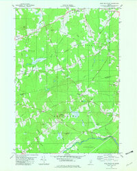
Newburgh Village and Winterport Sta anchor this 1982 topographical survey, which traces the transition from the rolling woodlands of Penobscot County into Waldo County. The landscape is defined by its corner settlements, such as Nealeys Corner and Ellingwood Corner, which serve as waypoints between the higher elevations of Snow Mountain and Kelly Mtn. Evidence of changing land use is visible in the presence of an Abandoned Airfield south of Alger Pond, contrasting with the more active recreation found at the Golf Course near West Hampden.
Find a feature on this map
48 named features on this map. Tap any name to fly to it.
Don’t see what you’re looking for? This feature index may not catch every label — zoom into the map to look around manually.
Map Details
Editions of this 1982 Snow Mountain Map
2 editions found

Other maps of this area

1900 · Bucksport
USGS Topo · 1:62,500

1902 · Bucksport
USGS Topo · 1:62,500

1902 · Bangor
USGS Topo · 1:62,500

1931 · Stetson
USGS Topo · 1:48,000

1932 · Brooks
USGS Topo · 1:62,500

1935 · Stetson
USGS Topo · 1:62,500

1942 · Bangor
USGS Topo · 1:62,500

1942 · Bucksport
USGS Topo · 1:62,500

1946 · Bangor
USGS Topo · 1:62,500

1948 · Bangor
USGS Topo · 1:250,000