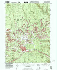
1996 Map of Snow Shoe
USGS Topo · Published 1999About this map
The borough of Snow Shoe serves as the central hub of this mid-1990s survey, situated along the southern edge of the plateau where the Allegheny Front meets the ridge and valley province. The landscape is a mix of industrial resource extraction and conservation, with extensive Strip Mine operations bordering the vast timberlands of Sproul State Forest and State Game Lands No 100. The settlement pattern follows the drainage of the North Fork Beech Creek and its tributaries, with small communities like Clarence, Gillintown, and Shettleston established near early mining and logging sites.
Find a feature on this map
48 named features on this map. Tap any name to fly to it.
Don’t see what you’re looking for? This feature index may not catch every label — zoom into the map to look around manually.
Map Details
Editions of this 1996 Snow Shoe Map
This is the sole edition of this map. No revisions or reprints were ever made.
Other maps of this area

1908 · Bellefonte
USGS Topo · 1:62,500

1909 · Bellefonte
USGS Topo · 1:62,500

1922 · Philipsburg
USGS Topo · 1:62,500

1928 · Snow Shoe
USGS Topo · 1:48,000

1929 · Karthaus
USGS Topo · 1:62,500

1931 · Show Shoe
USGS Topo · 1:62,500

1932 · Karthaus
USGS Topo · 1:62,500

1939 · Philipsburg
USGS Topo · 1:62,500

1943 · Lewistown
USGS Topo · 1:125,000

1945 · Philipsburg
USGS Topo · 1:62,500