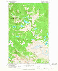
1966 Map of Snowking Mtn.
USGS Topo · Published 1968About this map
Snowking Mountain dominates this high-altitude landscape in the mid-1960s, serving as a focal point within the Glacier Peak Wilderness and Mt Baker National Forest. The survey reveals a complex network of alpine lakes and glacial drainage systems, including the nested Upper Granite Lake and Lower Granite Lake situated below Razorback Mountain. The map details the transition between protected wilderness and national forest land, marked by numerous isolated water bodies like Illabot Lake and Whale Lake. This 1966 field-checked data captures the area's hydrology before modern recreation impacts, showing the headwaters of Otter Creek and Boulder Creek as they descend from the high peaks. The topography is defined by significant elevations like Jordan Peak and Mt Chaval, providing a precise record of the granite basins and summits that define this portion of the North Cascades.
Find a feature on this map
41 named features on this map. Tap any name to fly to it.
Don’t see what you’re looking for? This feature index may not catch every label — zoom into the map to look around manually.
Map Details
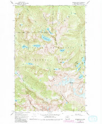
Editions of this 1966 Snowking Mtn. Map
3 editions found
Other maps of this area

1899 · Glacier Peak
USGS Topo · 1:125,000

1901 · Glacier Peak
USGS Topo · 1:125,000

1953 · Marblemount
USGS Topo · 1:62,500

1955 · Concrete
USGS Topo · 1:250,000

1958 · Concrete
USGS Topo · 1:250,000

1962 · Concrete
USGS Topo · 1:250,000

1963 · Sonny Boy Lakes
USGS Topo · 1:24,000

1963 · Eldorado Peak
USGS Topo · 1:24,000
1963 · Downey Mtn
USGS Topo · 1:24,000
1966 · Snowking Mtn.
USGS Topo · 1:24,000