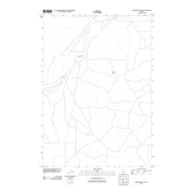
2010 Map of Snowshoe Butte
USGS Topo · Published 2010About this map
Snowshoe Butte and the surrounding high country of Fremont County are defined by a network of drainage patterns and ridge lines in this 2010 survey. The landscape is dominated by the course of Camas Creek, which winds through the central and northern sections of the quadrangle. This area of Idaho exhibits a sparse but structured transit network, where routes like Jacoby Rd and Gravy Ridge Rd provide access to the elevated terrain. To the east, the rise of Chicken Ridge serves as a prominent landmark, illustrating the transition between the creek valley and the higher plateau. The map details a largely undeveloped region where the economy and movement are dictated by the natural topography and the water system of the Snake River plain periphery.
Find a feature on this map
5 named features on this map. Tap any name to fly to it.
Don’t see what you’re looking for? This feature index may not catch every label — zoom into the map to look around manually.
Map Details
Editions of this 2010 Snowshoe Butte Map
This is the sole edition of this map. No revisions or reprints were ever made.
Other maps of this area

1955 · Dubois
USGS Topo · 1:250,000

1955 · Ashton
USGS Topo · 1:250,000

1958 · Dubois
USGS Topo · 1:250,000

1958 · Ashton
USGS Topo · 1:250,000

1960 · Ashton
USGS Topo · 1:250,000

1964 · Dubois NE
USGS Topo · 1:24,000
1964 · Dubois SE
USGS Topo · 1:24,000

1972 · Pine Butte
USGS Topo · 1:24,000
1972 · Split Rock
USGS Topo · 1:24,000
1972 · Snowshoe Butte
USGS Topo · 1:24,000