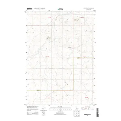
2013 Map of Snowshoe Butte
USGS Topo · Published 2013About this map
Snowshoe Butte and the surrounding high country of the Idaho-Montana borderlands define this portion of the Centennial Mountains range. The landscape is marked by the drainage of Camas Creek, which flows through the northern sections before winding toward the southwest. This 2013 survey illustrates a sparsely populated region where administrative lines like the Clark Co Fremont Co border intersect with a network of remote corridors including Jacoby Rd and Gravy Ridge Rd. The topography transitions from the elevated reaches of Chicken Ridge down into broad volcanic plains, reflecting the complex geology of the Snake River Plain's northern edge. Geographers and historians can trace the precise Public Land Survey System boundaries across townships T11N, T10N, and T9N, showing how these land divisions overlay the natural terrain of the high desert.
Find a feature on this map
13 named features on this map. Tap any name to fly to it.
Don’t see what you’re looking for? This feature index may not catch every label — zoom into the map to look around manually.
Map Details
Editions of this 2013 Snowshoe Butte Map
This is the sole edition of this map. No revisions or reprints were ever made.
Other maps of this area

1955 · Dubois
USGS Topo · 1:250,000

1955 · Ashton
USGS Topo · 1:250,000

1958 · Dubois
USGS Topo · 1:250,000

1958 · Ashton
USGS Topo · 1:250,000

1960 · Ashton
USGS Topo · 1:250,000

1964 · Dubois NE
USGS Topo · 1:24,000
1964 · Dubois SE
USGS Topo · 1:24,000

1972 · Pine Butte
USGS Topo · 1:24,000
1972 · Split Rock
USGS Topo · 1:24,000
1972 · Snowshoe Butte
USGS Topo · 1:24,000