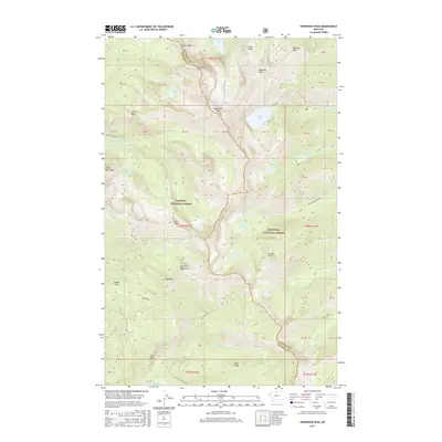
2017 Map of Snowshoe Peak
USGS Topo · Published 2017About this map
The Cabinet Mountains form a high-altitude spine through this portion of the Kootenai National Forest and Kaniksu National Forest. This 2017 survey details the complex hydrography of the range, where permanent ice features like the Blackwell Glacier feed alpine water bodies including Snowshoe Lake, Leigh Lake, and Big Cherry Lake. The high peaks, such as Snowshoe Peak and Alaska Peak, define a divide that separates the drainage basins of the N Fork Bull River and the Middle Fork Bull River. The map also captures the administrative boundary between Lincoln and Sanders counties as it traverses peaks like Dad Peak and Lentz Peak. This modern topographic study serves as a precise guide to the high-country terrain of the Cabinet Mountains Wilderness, marking the distinct ridges of Vimy Ridge and Flavel Ridge.
Find a feature on this map
70 named features on this map. Tap any name to fly to it.
Don’t see what you’re looking for? This feature index may not catch every label — zoom into the map to look around manually.
Map Details
Editions of this 2017 Snowshoe Peak Map
This is the sole edition of this map. No revisions or reprints were ever made.
Other maps of this area

1920 · Libby
USGS Topo · 1:125,000

1930 · Libby
USGS Topo · 1:125,000

1932 · Libby
USGS Topo · 1:125,000

1957 · Kalispell
USGS Topo · 1:250,000

1960 · Kalispell
USGS Topo · 1:250,000

1961 · Kalispell
USGS Topo · 1:250,000

1963 · Treasure Mountain
USGS Topo · 1:24,000
1963 · Crowell Mountain
USGS Topo · 1:24,000
1963 · Little Hoodoo Mountain
USGS Topo · 1:24,000
1966 · Ibex Peak
USGS Topo · 1:24,000