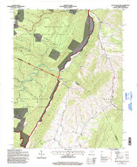
1995 Map of Snowy Mountain
USGS Topo · Published 1998About this map
Snowy Mountain and Lantz Mountain define the high ridges of the West Virginia-Virginia border during the mid-1990s. This survey area is bisected by the South Branch Potomac River, which cuts a narrow valley through the center of the sheet. Small communities like Dry Run and Hardscrabble are clustered along the river corridor and the lower slopes of Elk Mountain. The landscape is heavily protected by both the Monongahela National Forest and the George Washington National Forest, with numerous forest trails and remote drainage basins like Teeter Camp Run and Cold Spring Run. Local heritage is preserved in the location of several rural houses of worship, including Elk Mtn Chapel, Swank Chapel, and Dry Run Ch, while numerous small cemeteries mark the slopes above the settlements.
Find a feature on this map
49 named features on this map. Tap any name to fly to it.
Don’t see what you’re looking for? This feature index may not catch every label — zoom into the map to look around manually.
Map Details
Editions of this 1995 Snowy Mountain Map
This is the sole edition of this map. No revisions or reprints were ever made.
Other maps of this area

1889 · Beverly
USGS Topo · 1:125,000

1892 · Beverly
USGS Topo · 1:125,000

1892 · Franklin
USGS Topo · 1:125,000

1894 · Staunton
USGS Topo · 1:125,000

1896 · Franklin
USGS Topo · 1:125,000

1901 · Monterey
USGS Topo · 1:125,000

1922 · Spruce Knob
USGS Topo · 1:48,000

1922 · Circleville
USGS Topo · 1:62,500

1924 · Circleville
USGS Topo · 1:48,000

1924 · Mc Dowell
USGS Topo · 1:62,500