2024 Map of Snowyside Peak
USGS Topo · Published 2024About this map
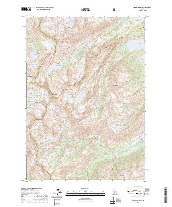
The Sawtooth Range dominates this high-altitude landscape, where the jagged crests of the Sawtooth Wilderness form a natural boundary between Blaine, Custer, Elmore, and Boise counties. Centered on the 10,651-foot summit of Snowyside Peak, the terrain is defined by a dense network of glacial basins and alpine lakes. A primary trail system, including the Alice-Toxaway Trl and Yellowbelly Trl, connects prominent water bodies like Alice Lake and Toxaway Lake, reflecting the area's importance for backcountry navigation and modern conservation.
Find a feature on this map
49 named features on this map. Tap any name to fly to it.
Don’t see what you’re looking for? This feature index may not catch every label — zoom into the map to look around manually.
Map Details
Editions of this 2024 Snowyside Peak Map
This is the sole edition of this map. No revisions or reprints were ever made.
Other maps of this area

1891 · Bear Valley
USGS Topo · 1:125,000

1893 · Bear Valley
USGS Topo · 1:125,000

1894 · Rocky Bar
USGS Topo · 1:125,000

1900 · Sawtooth
USGS Topo · 1:125,000

1919 · Custer
USGS Topo · 1:125,000

1922 · Custer
USGS Topo · 1:125,000

1955 · Hailey
USGS Topo · 1:250,000

1957 · Challis
USGS Topo · 1:250,000

1959 · Hailey
USGS Topo · 1:250,000

1960 · Challis
USGS Topo · 1:250,000