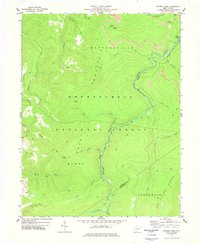
1977 Map of Snyder Knob
USGS Topo · Published 1977About this map
Shavers Fork flows through the center of this high-elevation terrain within the Monongahela National Forest during the mid-1970s. The landscape is defined by its massive ridges, including Huttonsville Mountain and Allegheny Mountain, which separate the various forks and runs of the upper Cheat River watershed. At the northern edge of the map, Cheat Bridge serves as a critical crossing point near the historic Fort Milroy Cem, a site linked to Civil War-era fortifications built to protect this mountain pass.
Find a feature on this map
33 named features on this map. Tap any name to fly to it.
Don’t see what you’re looking for? This feature index may not catch every label — zoom into the map to look around manually.
Map Details
Editions of this 1977 Snyder Knob Map
This is the sole edition of this map. No revisions or reprints were ever made.
Other maps of this area

1889 · Beverly
USGS Topo · 1:125,000

1891 · Huntersville
USGS Topo · 1:125,000

1892 · Beverly
USGS Topo · 1:125,000

1893 · Buckhannon
USGS Topo · 1:125,000

1894 · Huntersville
USGS Topo · 1:125,000

1896 · Buckhannon
USGS Topo · 1:125,000

1897 · Buckhannon
USGS Topo · 1:125,000

1901 · Monterey
USGS Topo · 1:125,000

1913 · Pickens
USGS Topo · 1:48,000

1915 · Pickens
USGS Topo · 1:62,500