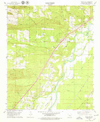
1978 Map of Social Hill
USGS Topo · Published 1979About this map
The Ouachita River defines the eastern boundary of this Arkansas landscape, carving a path through the lowland Black Flats and past the expansive Morrison Island. The terrain is characterized by a transition from the alluvial river bottoms to the elevations of Easely Mountain and Jack Mtn, where a Mountain Lookout Tower once monitored the surrounding timber. Settlement patterns follow the higher ground and historical routes like Military Road, with small communities such as Saginaw, Social Hill, and Oak Grove dotting the map. This 1970s record illustrates the localized industry of the era through numerous Gravel Pits and the proximity of the Missouri Pacific railroad. Genealogists will find several family-named burial sites and rural landmarks, including Lone Hill Cem, Ward Cem, and Neighbors Cem.
Find a feature on this map
49 named features on this map. Tap any name to fly to it.
Don’t see what you’re looking for? This feature index may not catch every label — zoom into the map to look around manually.
Map Details
Editions of this 1978 Social Hill Map
This is the sole edition of this map. No revisions or reprints were ever made.
Other maps of this area

1948 · Malvern
USGS Topo · 1:62,500

1949 · Malvern
USGS Topo · 1:62,500

1955 · Little Rock
USGS Topo · 1:250,000

1956 · Little Rock
USGS Topo · 1:250,000

1959 · Caddo Valley
USGS Topo · 1:24,000

1960 · Little Rock
USGS Topo · 1:250,000

1964 · Little Rock
USGS Topo · 1:250,000

1964 · Donaldson
USGS Topo · 1:24,000

1965 · Round Hill
USGS Topo · 1:24,000

1966 · De Roche
USGS Topo · 1:24,000