
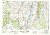
1954 Map of Socorro
USGS Topo · Published 1972About this map
The Rio Grande valley serves as a central artery for transportation and settlement in the mid-1950s, flanked by the Atchison Topeka And Santa Fe railroad and the historical villages of Belen, Isleta, and Los Lunas. This survey captures a transition between the irrigated valley floor and the high-desert mesa country, where expansive tribal lands like the Acoma Indian Reservation and Laguna Indian Reservation dominate the western horizon. To the east, the rugged peaks of the Manzano Mountains and Sandia Mts shelter early mountain communities including Tajique, Torreon, and Manzano.
Find a feature on this map
111 named features on this map. Tap any name to fly to it.
Don’t see what you’re looking for? This feature index may not catch every label — zoom into the map to look around manually.
Map Details
Editions of this 1954 Socorro Map
2 editions found
Other maps of this area

1883 · Mt. Taylor
USGS Topo · 1:250,000

1886 · Wingate
USGS Topo · 1:250,000

1886 · Mt. Taylor
USGS Topo · 1:250,000

1888 · Bernalillo
USGS Topo · 1:125,000

1889 · Albuquerque
USGS Topo · 1:125,000

1892 · San Pedro
USGS Topo · 1:125,000

1892 · Wingate
USGS Topo · 1:250,000

1892 · Mt. Taylor
USGS Topo · 1:250,000

1893 · Albuquerque
USGS Topo · 1:125,000

1894 · Lamy
USGS Topo · 1:125,000