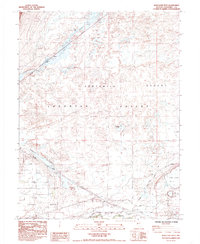
1985 Map of Soda Lake West
USGS Topo · Published 1985About this map
The Pioneer California Emigrant Trail and the Carson River Route converge in this arid landscape, marking a vital historical corridor through the Fortymile Desert. The settlement of Ragtown sits along the Carson River, a location where travelers on the overland trails famously rested after the grueling desert crossing. This 1980s-era survey details the complex hydrology of the Lahontan Valley, where the Southern Pacific railroad follows the path of the Massie Slough past the siding at Massie. To the south, the Swingle Bench and the cluster of buildings at Swingle represent the agricultural and ranching efforts supported by the river. The map also features the distinctive depressions of Soda Lake and Little Soda Lake, alongside markers for historical monuments that preserve the legacy of the emigrant experience in Churchill County.
Find a feature on this map
28 named features on this map. Tap any name to fly to it.
Don’t see what you’re looking for? This feature index may not catch every label — zoom into the map to look around manually.
Map Details
Editions of this 1985 Soda Lake West Map
This is the sole edition of this map. No revisions or reprints were ever made.
Other maps of this area

1890 · Wadsworth
USGS Topo · 1:125,000

1891 · Wabuska
USGS Topo · 1:125,000

1892 · Wadsworth
USGS Topo · 1:125,000

1894 · Wadsworth
USGS Topo · 1:125,000

1894 · Wabuska
USGS Topo · 1:125,000

1908 · Carson Sink
USGS Topo · 1:250,000

1910 · Carson Sink
USGS Topo · 1:250,000

1951 · Soda Lake
USGS Topo · 1:62,500

1951 · Fallon
USGS Topo · 1:62,500

1957 · Two Tips
USGS Topo · 1:62,500