
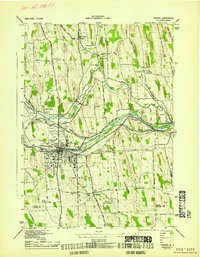
1943 Map of Sodus
USGS Topo · Published 1943About this map
Salmon Creek carves a central path through this Wayne County landscape, where the agricultural and industrial patterns of the early 1940s are meticulously documented. The village of Sodus serves as the primary hub, situated along the New York Central line and State Street. The map reveals a highly developed rural infrastructure defined by an exceptional density of local schoolhouses, ranging from School No 5 in the northwest to School No 9 near the southern border.
Find a feature on this map
48 named features on this map. Tap any name to fly to it.
Don’t see what you’re looking for? This feature index may not catch every label — zoom into the map to look around manually.
Map Details
Editions of this 1943 Sodus Map
This is the sole edition of this map. No revisions or reprints were ever made.
Other maps of this area

1899 · Palmyra
USGS Topo · 1:62,500

1902 · Sodus Bay
USGS Topo · 1:62,500

1902 · Pultneyville
USGS Topo · 1:62,500

1902 · Clyde
USGS Topo · 1:62,500

1902 · Palmyra
USGS Topo · 1:62,500

1942 · Pultneyville
USGS Topo · 1:31,680

1943 · Lyons
USGS Topo · 1:31,680

1943 · Williamson
USGS Topo · 1:31,680

1943 · Sodus Point
USGS Topo · 1:31,680
1943 · Newark
USGS Topo · 1:31,680