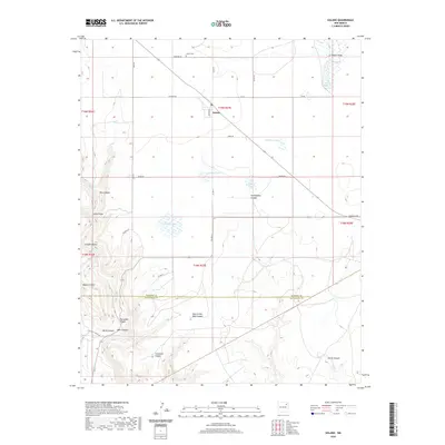
2020 Map of Solano
USGS Topo · Published 2020About this map
Solano sits at the intersection of high plains and deeply incised canyonlands in this northern New Mexico landscape. The settlement is centered near the junction of several county roads, including Madison St and La Pompa Rd, serving as a localized hub in the ranching country of Harding and San Miguel Counties. A series of natural ephemeral basins such as Ladd Lake, Callahan Lake, and Church Lake dot the flatter northern reaches, providing vital water sources in this arid environment. To the south, the topography breaks sharply into a complex system of drainages. Significant geological features like Mesa Cortada and the hidden depths of Hole-In-the-Wall Canyon and Devils Canyon illustrate the erosional forces at work. The map also records local landmarks such as the Solano Cem, situated north of the main townsite near Cemetary Rd.
Find a feature on this map
41 named features on this map. Tap any name to fly to it.
Don’t see what you’re looking for? This feature index may not catch every label — zoom into the map to look around manually.
Map Details
Editions of this 2020 Solano Map
This is the sole edition of this map. No revisions or reprints were ever made.
Other maps of this area

1954 · Santa Fe
USGS Topo · 1:250,000

1954 · Tucumcari
USGS Topo · 1:250,000

1958 · Santa Fe
USGS Topo · 1:250,000

1958 · Tucumcari
USGS Topo · 1:250,000

1969 · Chinaberry Canyon
USGS Topo · 1:24,000

1972 · Montoya Point
USGS Topo · 1:24,000

1972 · Waggoner Ranch
USGS Topo · 1:24,000

1973 · Mosquero
USGS Topo · 1:24,000

1973 · Sabino
USGS Topo · 1:24,000
1974 · Roy
USGS Topo · 1:24,000