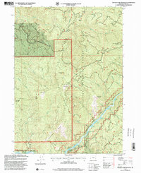
1998 Map of Soldier Camp Mountain
USGS Topo · Published 2001About this map
Siskiyou National Forest land dominates this section of Curry County, where the terrain rises sharply from the riverbanks to prominent peaks. The southern portion of the map is defined by the Rogue River, a designated Rogue National Wild and Scenic River corridor. Navigating this stretch of water requires knowledge of numerous named features such as Shingler Riffle, Upper Coal Riffle, Lower Coal Riffle, and Rachels Delight Riffle. Away from the water, the landscape is marked by high-elevation points like Soldier Camp Mountain and Potato Illahe Mountain. The distribution of several Quarries across the slopes suggests the ongoing importance of resource extraction and road maintenance in this mountainous forest environment, while remote locations like Steffin Meadow offer a glimpse into the isolated meadows found between the ridges.
Find a feature on this map
38 named features on this map. Tap any name to fly to it.
Don’t see what you’re looking for? This feature index may not catch every label — zoom into the map to look around manually.
Map Details
Editions of this 1998 Soldier Camp Mountain Map
This is the sole edition of this map. No revisions or reprints were ever made.
Other maps of this area

1899 · Port Orford
USGS Topo · 1:125,000

1903 · Port Orford
USGS Topo · 1:125,000

1954 · Coos Bay
USGS Topo · 1:250,000

1954 · Port Orford
USGS Topo · 1:62,500

1954 · Gold Beach
USGS Topo · 1:62,500

1954 · Collier Butte
USGS Topo · 1:62,500

1954 · Agness
USGS Topo · 1:62,500

1958 · Coos Bay
USGS Topo · 1:250,000

1962 · Coos Bay
USGS Topo · 1:250,000
1986 · Father Mountain
USGS Topo · 1:24,000